120 Tioga Pass travel guide for scenic road trips
Tioga Pass is one of those drives that reminds you why road trips still matter. It is not just a way to get from point A to point B; it is a high-elevation route through granite domes, alpine meadows, polished lakes, and views that seem to reset your sense of scale. If you are planning a scenic drive in California, Highway 120 across Yosemite National Park deserves a place near the top of the list.
As someone who has spent enough time in the field to know that a “short scenic stop” can turn into a two-hour detour with a perfect view, I can tell you this: Tioga Pass rewards travelers who plan ahead. It is beautiful, yes, but it also comes with seasonal closures, weather changes, and road conditions that can shift quickly at higher elevations. If you approach it with the right timing and expectations, it is one of the finest mountain drives in the American West.
What Tioga Pass actually is
Tioga Pass is the eastern entrance to Yosemite National Park along Highway 120, crossing the Sierra Nevada at an elevation of about 9,945 feet. It connects the Yosemite Valley side of the park with the high desert landscapes near Lee Vining and Mono Lake on the eastern slope. In practical terms, it is a trans-Sierra route. In travel terms, it is a showcase of how much terrain can change in a single day’s drive.
What makes this route special is the contrast. On one side, you have the granite and forests of Yosemite. On the other, you drop into the drier, broader landscapes of the eastern Sierra. The drive feels like moving through several ecosystems in a few hours, which is exactly why it is such a strong fit for scenic road trips.
Best time to drive Tioga Pass
Timing is everything here. Tioga Pass is generally open only from late spring through fall, depending on snowpack and plowing conditions. In heavy snow years, opening can be delayed well into June. Closing often happens in November, sometimes earlier if storms arrive quickly. Mountain weather does not care about your itinerary, which is part of the charm and part of the problem.
The best window for most travelers is from late June through September. During this period, roads are usually open, trailheads are accessible, and alpine lakes are free of snow. July and August are the warmest and most reliable months, but they are also the busiest. If you want lighter traffic and cooler temperatures, aim for early summer or early fall.
One practical note: even in summer, mornings can be chilly at elevation. I have seen people step out of their cars in shorts and T-shirts only to grab every extra layer they packed ten minutes later. At 10,000 feet, the weather can shift from pleasant to brisk without asking permission.
Why this route works so well for scenic road trips
Tioga Pass is not a long drive by mileage alone, but it is dense with scenery. That matters for road trippers. You are not just passing through empty miles; you are moving through a series of viewpoints and short stops that give the route real structure.
For a scenic drive, the essentials are simple: variety, accessibility, and memorable pull-offs. Tioga Pass has all three. You get mountain lakes, broad overlooks, glacially carved granite, and opportunities to stretch your legs without committing to a full-day hike. That makes it ideal for travelers who want big scenery without turning the trip into a logistics puzzle.
It is also a good route for drivers who appreciate pacing. There are enough places to stop that you can build a relaxed itinerary. You do not need to rush, and in fact, you should not. The pass is best experienced at a steady pace, with time to step out, breathe the thin air, and take in the scale of the place.
Top stops along Highway 120
Several stops make the route especially worthwhile. If you are planning the drive, these are the places that consistently deliver value.
-
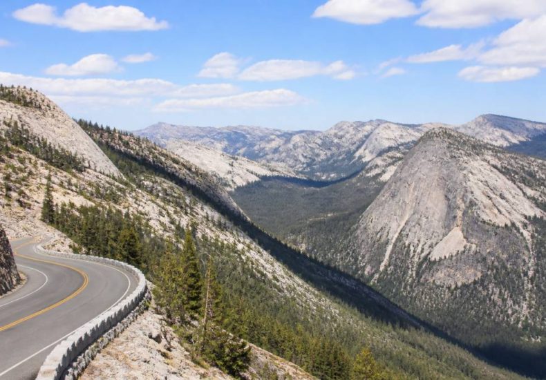
Olmsted Point: This is one of the most famous viewpoints on the Tioga Road. It offers a broad look at Half Dome from the northern side, along with polished granite and scattered pines. It is a straightforward stop with a big visual payoff.
-
Tenaya Lake: A classic alpine lake stop with easy access and a spectacular setting. The lake sits right along the road, making it a great place for a picnic or a quick walk to the shore.
-
Tuolumne Meadows: One of the largest high-elevation meadows in the Sierra, Tuolumne Meadows is a good place to slow down, explore short trails, and get a feel for the alpine environment. In late summer, the light here can be excellent for photography.
-
Tioga Lake: Located near the eastern approach, this stop offers quieter scenery and easy access from the highway. It is especially appealing if you are entering Yosemite from the east and want a first glimpse of the high country.
-
Mono Lake and Lee Vining: Just beyond the pass, these destinations make an excellent extension to the drive. Mono Lake’s tufa towers are geologically distinctive and highly photogenic, and Lee Vining is a practical place for fuel, food, and supplies.
Road trip planning essentials
High-elevation driving requires a little more preparation than a standard freeway cruise. The basics matter here. Check road status before you go, confirm your fuel level, and make sure your vehicle is ready for mountain conditions. This is not the place to assume that the next gas station is always “just around the corner.” Sometimes the corner is 30 miles away.
If you are traveling in peak season, start early. Morning light is better for photos, traffic is lighter, and you give yourself more flexibility if you decide to linger at a viewpoint or trailhead. Starting early also helps you avoid the busiest parking areas around Tenaya Lake and Tuolumne Meadows.
Pack water, snacks, sunscreen, and layers. The air is dry and the sun is intense at elevation, even when temperatures feel moderate. A light jacket, hat, and sunglasses are simple items that make the drive more comfortable. If you plan to stop for short walks, bring footwear that can handle uneven ground and maybe a bit of dust.
Short hikes worth adding to the drive
One of the smartest ways to use Tioga Pass is to combine the drive with a short hike or two. You do not need a full backpacking itinerary to enjoy the area. In fact, some of the best experiences are reachable from the roadside with minimal effort.
Popular options include the path around Tenaya Lake, short walks in Tuolumne Meadows, and the nearby trailheads for visitors who want a bit more time on foot. These hikes are especially good for families or road trippers who want to balance driving with movement. The terrain is gentle in some places and more rugged in others, so choose based on your energy level and time.
If you are the type who cannot resist “just one more viewpoint,” this region is ideal. The trails are often short, scenic, and easy to fit into a day. That said, even easy hikes at this elevation can feel harder than expected. Altitude changes the game. Walk at a measured pace and keep an eye on how everyone in your group is handling the air.
Wildlife and natural features to watch for
Tioga Pass is not only about the views. It is also a strong place to observe alpine ecology up close. You may see mule deer, marmots, pikas, and a variety of birds adapted to high-country life. In meadows and near water, wildlife activity can be especially noticeable in the early morning and late afternoon.
Do not approach animals for photos. That should go without saying, but in popular areas, some visitors still forget. Wildlife in Yosemite and the eastern Sierra is accustomed to people, which does not mean it should be treated like a photo prop. A telephoto lens is useful, as is a bit of patience.
Botanically, the area changes rapidly with elevation and exposure. You will notice subalpine forests, meadows, exposed granite, and patches of wildflowers depending on the season. For travelers interested in nature, Tioga Pass is a compact lesson in mountain ecology. It is one reason the route holds up so well for repeat visits; the landscape looks different every time you come through.
Photography tips for the route
Tioga Pass is excellent for photography, but the conditions can be demanding. The contrast between bright sky, reflective granite, and shadowed trees can be tricky for exposure. If you shoot on a phone, tap to focus carefully and consider lowering exposure slightly to preserve highlights. If you use a camera, bracket your shots when the light is harsh.
Early morning and late afternoon are the best times for softer light and deeper color. Midday can still work, especially for wide landscape shots, but the light tends to be flatter. At spots like Olmsted Point and Tenaya Lake, the golden hour can produce strong reflections and warm tones. On clear days, the eastern side of the pass often gives you excellent long-distance visibility.
If you are building a photo stop list, prioritize places where you can safely pull over and step away from traffic. Scenic beauty is great, but so is not standing in the road. A little common sense goes a long way when you are trying to get the perfect shot.
Driving considerations for safety and comfort
Mountain driving is straightforward if you respect the terrain. Keep your speed conservative, watch for sharp curves, and stay alert for cyclists, wildlife, and slower vehicles. On busy days, passing opportunities can be limited, so patience helps more than horsepower.
Elevation can affect both drivers and vehicles. Some people notice fatigue, mild headaches, or shortness of breath. Take breaks, hydrate, and avoid overdoing it if you are not used to high altitude. As for the car, make sure your brakes are in good condition and your tires are properly inflated. The drive is paved and generally well maintained when open, but the usual mountain-road caution still applies.
Weather deserves special attention. Even during open season, storms can bring sudden changes in visibility and road traction. Check forecasts from a reliable source, and if conditions look questionable, adjust your schedule rather than forcing the issue. The mountains will still be there tomorrow.
Suggested road trip pairings
Tioga Pass works beautifully as part of a larger route. If you are designing a scenic drive, consider pairing it with one of these options:
-
Yosemite Valley to Mono Lake: A classic cross-Sierra route with dramatic transitions from forested valley to alpine terrain to high desert.
-
Tioga Pass to June Lake Loop: A strong add-on if you want more eastern Sierra scenery, lakes, and a slower pace after crossing the pass.
-
Lee Vining to Mammoth Lakes: This extension gives you more mountain scenery and access to additional outdoor stops.
-
Yosemite road trip with a stop at Mono Basin: Ideal for travelers who want natural history, photography, and a different geological setting in one trip.
For many travelers, the best experience is not simply driving Tioga Pass and leaving. It is using the route as the backbone of a broader Sierra itinerary. That is where the road really shows its value.
What to remember before you go
Tioga Pass is scenic, practical, and rewarding, but it asks for planning. Confirm that Highway 120 is open, start early, pack for changing weather, and make time for the worthwhile pull-offs. If you do that, the route becomes much more than a transit corridor. It becomes a highlight of the trip.
From a travel perspective, this is one of the best mountain drives in California because it balances accessibility with genuine wilderness character. You do not need to be an expert hiker or an experienced off-road traveler to appreciate it. You just need a good map, a full tank of gas, and the willingness to stop when the view tells you to.
And if you hear someone in the car say, “Let’s just make one quick stop,” be warned: on Tioga Road, that phrase has a habit of aging poorly.